
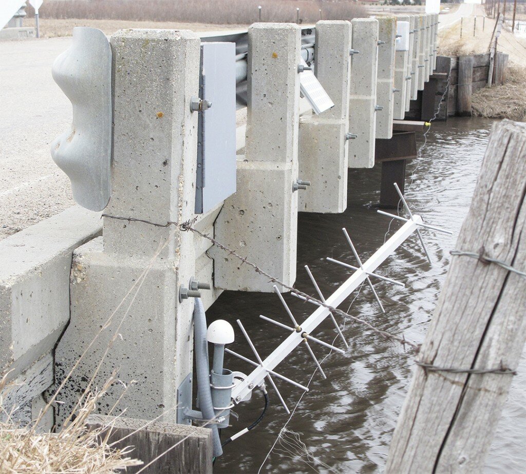
BROOKINGS – As you cross a bridge spanning a river, you might notice the very tip of an antenna peeking out near the guardrail. As odd as it might seem, it’s the sign of an important tool that’s helping a variety of agencies collect data on waterways: a stream gauge.
This item is available in full to subscribers.
To continue reading, you will need to either log in to your subscriber account, or purchase a new subscription.
If you are a current print subscriber, you can set up a free website account and connect your subscription to it by clicking here.
If you are a digital subscriber with an active, online-only subscription then you already have an account here. Just reset your password if you've not yet logged in to your account on this new site.
Otherwise, click here to view your options for subscribing.
Please log in to continue |
BROOKINGS – As you cross a bridge spanning a river, you might notice the very tip of an antenna peeking out near the guardrail. As odd as it might seem, it’s the sign of an important tool that’s helping a variety of agencies collect data on waterways: a stream gauge.
Most stream gauges collect two main points of data: how high the water level is and how much water is flowing at that spot in cubic feet per second. The gauges collect the relevant data at points throughout the day, and as years or even decades of data is collected, trends can be established.
Stream gauges are typically owned by either the U.S. Geological Survey, the South Dakota Department of Environment and Natural Resources, or East Dakota Water Development District. To cut costs, the gauge owner typically partners with another one of the entities.
Brookings County has two new stream gauges installed (one on Six Mile Creek, north of the Brookings Landfill, and the other on North Deer Creek) and another will soon be added somewhere along Medary Creek.
Owned by the USGS, these three are among the 20 stream gauges to be added to the 30 already in place in the Big Sioux River basin.
These new gauges are part of a state-driven response to the shortcomings of the flood model that was in place during a flood in 2014.
In early June 2014, it rained heavily for a couple of days south of Sioux Falls.
“A tremendous amount of water came through the (Big Sioux River) system,” Jay Gilbertson, manager and treasurer of the East Dakota Water Development District, said. “Stream gauges in that part of the world were measuring record flows, and, in fact, one gauge on the Rock River basically shut down.
“The prediction at that time was that water would rise to a point where it would inundate the interstate and the railroad. So, the decision was made to close the interstate for a little over 24 hours,” he said.
The flood model predicted that the water moving through the Big Sioux River basin would stay constrained in a similarly narrow area, not taking into account that once it reached the Missouri River, the water could spread out over a much greater area, unexpectedly minimizing the severity of flooding in the Sioux City area.
“When the crest came through, it didn’t get that high. That’s a good thing, but shutting down the interstate for 24, 36 hours and having trucks drive around that, the economic destruction was phenomenal,” Gilbertson said.
And so in this context, there was a call for more accurate flood modeling, resulting now in new stream gauges being installed across the Big Sioux River basin.
The form a stream gauge takes varies depending on how new they are.
Older stream gauges are housed in a compact station that resembles an outhouse placed on top of a concrete platform along a waterway; if the equipment can transmit its data remotely, it even has an antenna affixed to it.
In the old days, these little stations recorded water level data with a drum recorder that used large rolls of paper and a pen, thus requiring the large space.
That’s not needed these days, however, so newer stations can have much smaller footprints. Housed in a nondescript small metal box, these are locked and tucked away as much as possible so as to avoid tampering or vandalism. Even though this slimmer modern housing looks different from the older ones, their purpose is the same.
What can be a problem for older stations that have been in place for as much as 80 years in some cases, is the changing of a river’s path. Changes like that can, sometimes significantly, alter what is considered normal at that spot, making old data irrelevant.
In these cases, old data is cycled out in order to better reflect the new situation of the river and achieve more accurate averages.
“If we know there’s been a significant channel geometry change, they may take a big chunk of the old data out of the mix from that point forward. It was perfectly good data at the time it was collected, but at this point, it doesn’t really tell us about anything that’s going on,” Gilbertson said.
As useful as stream gauges are in helping predict future floods, they also help out when water samples are taken by putting the results into perspective.
If a sample is taken from a river with a large volume of water moving through, then “even a small amount of contaminant in the sample spread out over that whole, if it’s representative, we could have a huge load of contaminants coming down the river,” Gilbertson said. “By that same token, if we take our little sample and it takes me five minutes to collect that same amount of water, the treat and risk is tiny.”
But no matter why someone might need its data, the humble stream gauge will be there along the water, keeping an eye on things, just in case.
Contact Eric Sandbulte at esandbulte@brookingsregister.com.
Eric Sandbulte/Register
Stream gauges are important tools for collecting data on water levels and the volume of water passing through the spot. A stream gauge, complete with an antenna so its data can be transmitted, is attached to a bridge and sits above the high waters of Six Mile Creek north of the Brookings Landfill. It was installed earlier in the year as part of a state-wide push to collect more data in order to create more accurate flood prediction models.


