For the Brookings Register
Summer officially started on June 20 — so, this week's subject is summer preparedness.
Brookings County is part of the National Weather Service’s Weather-Ready Nation …
This item is available in full to subscribers.
To continue reading, you will need to either log in to your subscriber account, below, or purchase a new subscription.
Please log in to continue |
Summer officially started on June 20 — so, this week's subject is summer preparedness.
Brookings County is part of the National Weather Service’s Weather-Ready Nation Ambassador program. The NWS is part of the National Oceanic and Atmospheric Administration and falls under the U.S. Department of Commerce.
With temperatures rising and the threat of thunderstorms increasing each day, I plan on updating you with a series of summer-related safety and preparedness materials over the next few weeks. Topics to be covered include basic safety and preparedness information, a review of watch and warning definitions, severe weather hazards (wind, hail, tornadoes, and floods), lightning and heat.
Let’s start with basic preparedness and some common definitions. Now is the perfect time of year to ensure you have multiple ways of receiving watch and warning information. You never know if the one thing you normally count on will be available when hazardous weather strikes. A NOAA All Hazards Radio — also known as a weather radio — smartphone apps, social media, your local newspaper and your local television or radio station are all great ways to stay informed. Please note that some social media posts can be outdated. Always look for the time the information is posted.
The NWS does not have a smartphone app. Numerous apps are available for weather information, but I do not use an app for my weather messages. I trust in the NWS and the messages that I send are always produced by the NWS.
The National Weather Service has three South Dakota offices: Aberdeen, Rapid City and Sioux Falls. They are staffed by meteorologists who provide a 24-hour-a-day weather watch. One of the duties of the local office is to provide severe thunderstorm and tornado warnings for the county in which you live.
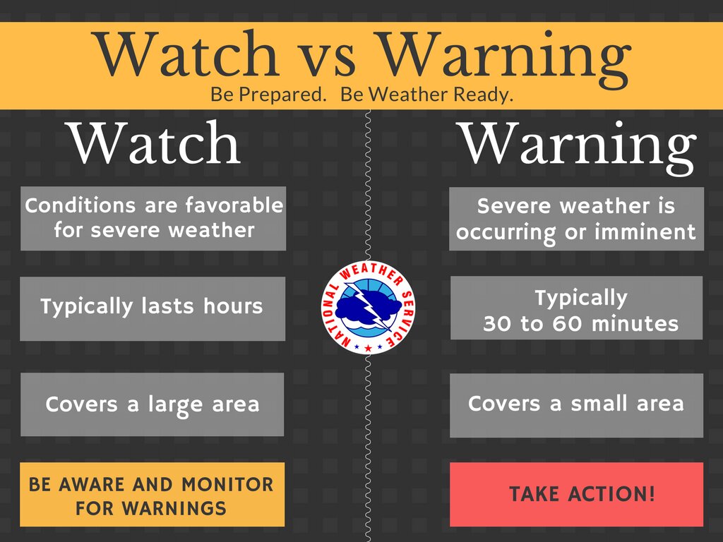
All warnings for Brookings County are issued by the NWS office in Sioux Falls. The storm prediction center, also an NWS office, is located in Norman, Oklahoma, and its main function is to issue severe thunderstorm and tornado watches, as well as severe weather outlooks for the entire nation. Remember, a watch is issued when conditions over a large area are favorable for severe weather, so begin to prepare and keep an eye on the sky. A warning is issued when severe weather has been reported or detected by radar, so move immediately to your shelter location. Also, remember that a watch does not need to precede a warning. If a warning is issued, listen to it and then take action.
The three most common summertime hazards that result in a watch or warning include severe thunderstorms, tornadoes and flash floods.
A thunderstorm is considered severe, and a warning will be issued, if it produces hail one inch in diameter or greater and/or wind gusts to 58 mph or greater. Hail one inch in diameter is the size of a quarter and the threshold at which damage to vehicles and roofing material becomes more likely. The larger the hailstone, the greater potential there is for damage. At the same time, tree branches roughly the diameter of your wrist begin to snap once wind gusts reach 58 mph. The likelihood of more significant damage, especially to structures, increases with wind speed. It is important to take severe thunderstorms seriously by immediately seeking shelter indoors, and away from windows, after receiving a warning.
Tornadoes are violently rotating columns of air in contact with the ground. Potentially the most destructive of any summertime hazard, tornadoes are rated on the Enhanced Fujita Scale based on observed damage from 0 (weak) to 5 (very strong). The safest place to seek shelter from a tornado is in an underground shelter or basement. If a basement is not available, seek shelter in a small, interior room (i.e. bathroom or closet) on the lowest level of a structure. Mobile homes are unsafe and alternative sheltering sites should be identified well before a tornado strikes.
A flash flood is a rapid and extreme flow of high water into a normally dry area beginning within six hours of the causative event. Flash floods are most often caused by very heavy rainfall but can also be the result of a dam failure. Most fatalities related to flash flooding occur when people drive into flooded areas since it only takes 12 to 24 inches of moving water to turn most vehicles into boats. Turn around, don’t drown. Not only is it difficult to know the depth of water over a road, but the roadway itself may be washed out. Find a different way to reach your destination — it’s just not worth the risk.
I would like to thank the Sioux Falls NWS for providing input for this week's article.
Until next time, keep an eye on the sky. Bob the EM.